Shibuya Bridge ", a new commercial facility under construction at the Toyoko Line · Railway site, approaches the mystery of the design drawing" R "!
On May 24 th (Thursday), the name of the facility of the Shibuya redevelopment area "Shibuya Daikanyama R Project" scheduled to open in the autumn is decided as "Shibuya Bridge" and the progress of the construction has been released for the press.
Currently, in the redevelopment work around Shibuya Station " SHIBUYA SCRAMBLE SQUARE " " SHIBUYA STREAM " "Dog 玄 saka 1-chome Ekimae Block (Tokyu Plaza ruins)" "Shibuya Station Sakuragaokaguchi District" "Shibuya Miyashitacho Plan (Toei Miyashitacho Apartment ruins)" Because there are various facility names and project names flying around, there are probably many people who do not know exactly where development is.
So first, where is "Shibuya Bridge (Shibuya Daikanyama R Project)"? I would like to confirm from that position.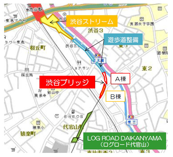 ▲ Location of "Shibuya Bridge" (Image offer = Shibuya Bridge)
The newly-named “Shibuya Bridge” is the same as the large-scale commercial facility “ SHIBUYA STREAM ” in which Google Japan's corporate residence is decided, along with the undergroundization between TOKYU TOYOKO LINE and Shibuya Station to Daikanyama Station. It is one of the redevelopment projects of the newly created ground track track site.
From " SHIBUYA STREAM " which is close to Shibuya station, Shibuya Bridge is located ahead of the Namiki Bridge, about 600 meters to the Ebisu / Daikanyama area along the newly created promenade along the Shibuya River. Speaking of a place adjacent to the "Shibuya Cleanup Factory" where a big chimney stands up might be easy to understand.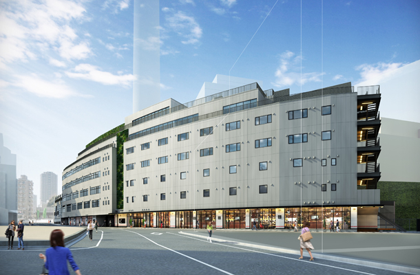 ▲ Shibuya Bridge B Building Exterior Image (Image Provision = Shibuya Bridge)
I would like you to see Perth of the completed figure. The appearance makes a curve like a Roman Colosseum. Although it is a very unique design, in reality there are good reasons why the building is curving.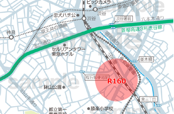 Toyoko Line departs from Daikanyama Station, and just turns the curve to the left to change the course from this area to Shibuya station direction. If you are a railroad fan you know. The sharp curve of "R160 (curved radius 160m)" is known as the biggest difficulty of the Toyoko line, braking the "key, key ......" around this point, and then rush into the curve after slowing down. The reverberating brake sound is memorable for now. The curve of the facility can be said to be a remnant that reminds of the Toyoko Line which once ran on the ground.
But why did I have to draw such a large curve in the section from Daikanyama station on Toyoko Line to Shibuya station?
Let's understand the history a little. How was the plan of the Toyoko Line considered in the first place? According to the company history of "Musashi Electric Railway," which is the predecessor of TOKYU CORPORATION Corporation, Hiroo and Tengenji (per the current Hiroo Hospital) from around 1906 to Shibuya Bridge and Ebisu area, and then Hiranuma Station in Yokohama (now There is a record of having obtained a license for the section to the west of Yokohama Station). It is probable that the route from Tokyu-Nakameguro Station to Ebisu and Hiroo will be taken, and a route close to the current Hibiya Line is planned. Originally Toyoko Line was not going to make "Shibuya" terminal station. Various problems such as financing and land acquisition have arisen and construction may not proceed, and as a result, it may not have been forced to give up extension to the east. If you think so, you can understand that “Shibuya”, which is easy to connect to the YAMANOTE LINE line, is chosen as the final destination along the Shibuya River, where land acquisition is easy.
Although it does not go out of the guessing range to the last, it seems that the large curve of "R160" between Daikanyama station and Shibuya station is a testimony of the transition that had forced the plan to change. After that, in 1927 the Tokyo Yokohama Railway (now Tokyu Corporation) started a direct drive between Shibuya station and Kanagawa station, and today the city of Shibuya is born. To the west, east, or exactly Shibuya, it can be said that it is a curve that should be called a fate separator.
Another thing I would like to touch on topics related to large curves. There used to be "Namiki bridge station" between Daikanyama and Shibuya station (For Namiki-bashi station, I write another article,therePlease refer to).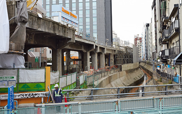 ▲ The protruding part before the high bridge is the remnant of former JR Kyobashi station (around the shooting date around March 2014)
There was Namiki-bashi station, located just in front of the Koike liquor store along the Shibuya River, near the Namiki bridge just beyond the "R160" curve. Why was it necessary to make another station within a short section of about 1.4 km between Daikanyama and Shibuya station. Since there were many schools including Aoyama Gakuin and Practical Girls' School, Tokiwa Matsujo Gakuin, Kokugakuin College from the time since that time, it can be thought that it assumed that students were used. , But in fact it is safe to travel the large curve of "R160", it is speculated that the station was once stopped by increasing one station. The period of operation of Nikihashihashi Station was only 18 years from 1927 when opening the Toyoko Line to 1945 when it was damaged by the Tokyo Air Bombardment. The area will be reborn as a promenade following redevelopment, but I would like to dare mention here that there was "Namiki Bridge Station" in this place as a memory of the city here.
<Articles>
In the past, there was "Namiki bridge station" between Shibuya and Daikanyama! Let's memorize the memories of Phantom station (published in March 2014)
https://www.shibuyabunka.com/special/201403/part4.html
Well, let's return the story to the present at once. The new commercial facility newly born in this "R160" is "Shibuya Bridge".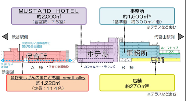 Shibuya Bridge Application Image (Image Provision = Shibuya Bridge)
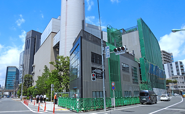
Complex facility consisting of buildings of three buildings, A building and seven stories building B. The hotel "MUSTARD HOTEL (mustard hotel)" to be a accommodation facility for foreign travelers such as nursery school type accredited kindergarten in building A and backpacker in building A will be opened, and offices, cafes, etc. will move in Has been decided.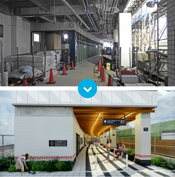 (Upper) Construction landscape of building A opened to the press on May 24 (Thu).
(Below) Shibuya Bridge A building. A completed image of the free passage continuing from the boardwalk. The width is about 10 meters, which shows what the vertical lines of Toyoko Line had been running. (Image offer = Shibuya Bridge).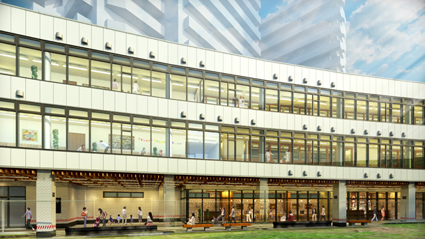 ▲ Shibuya Bridge Certification Children's Garden Opening A Building Exterior Image (Image Provision = Shibuya Bridge)
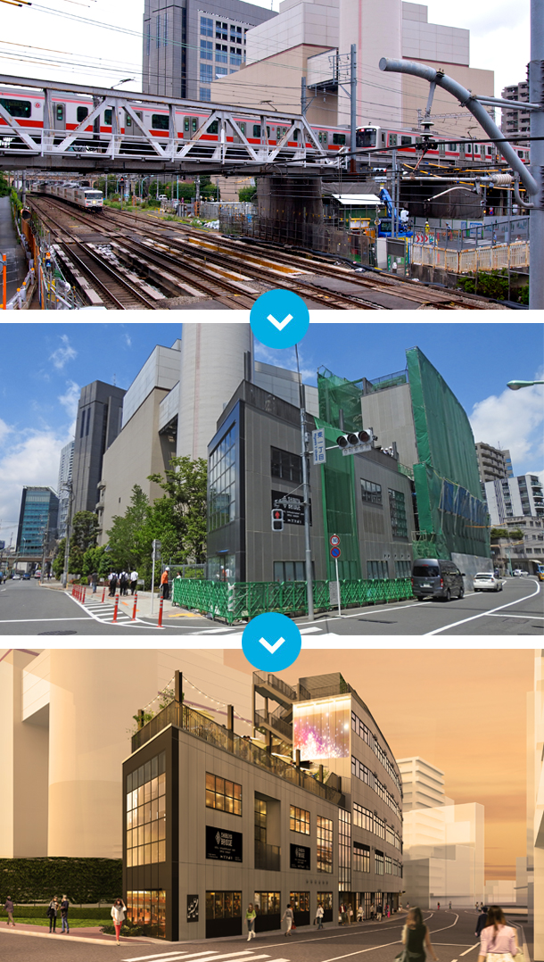 (Top) Toyoko Line running on a truss bridge intersecting with JR (shooting taken on September 16, 2012)
(Middle) Under construction "Shibuya Bridge" (shooting on May 24, 2018)
(Bottom) Shibuya Bridge B building exterior image viewed from Daikanyama side (Image offer = Shibuya Bridge) The facility name "Shibuya Bridge" has two meanings, "bridge to multi-generation / cross-cultural" and "bridging" of areas with different faces such as Shibuya and Daikanyama. The logo is a combination of "S" and "B" in the initials of "SHIBUYA BRIDGE", which is a rhombus that imaged railway signs. In addition, underlining "R" emphasizes the words "Reborn", "Relay" and "Rail-Road" and inheriting the curve of "R160" It says that.
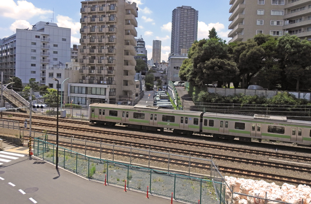 眺望 View from the roof balcony of “Shibuya Bridge”. The other side of YAMANOTE LINE is Daikanyama area. The center of the photo is "Log Road Daikanyama," which opened in June 2015 (opened in June 2015).
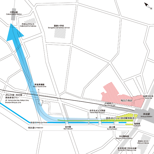 ▲ The flow of new people is born from Shibuya to Daikanyama. (Image offer = Tokyo Tokyu Corporation)
Until now, the town of Shibuya is the main side with Hachiko open space and park street, while the east exit and south entrance faces were not too few people who had the impression of being "behind Shibuya" or "B side of Shibuya" Is not it? The opening of " SHIBUYA STREAM " and "Shibuya Bridge" that will open this autumn will greatly expand the commercial area in the south area of Shibuya station and it will become a hub to create a new flow of people from Shibuya to Daikanyama and Ebisu It is expected. Shibuya this fall seems to be unable to keep an eye on the South area.

Editorial department · Fuji Itakashi
Shibuya registrar. In addition to Shibuya of Culture information, seasonal news and topics, it will spell write that feel every day.
